
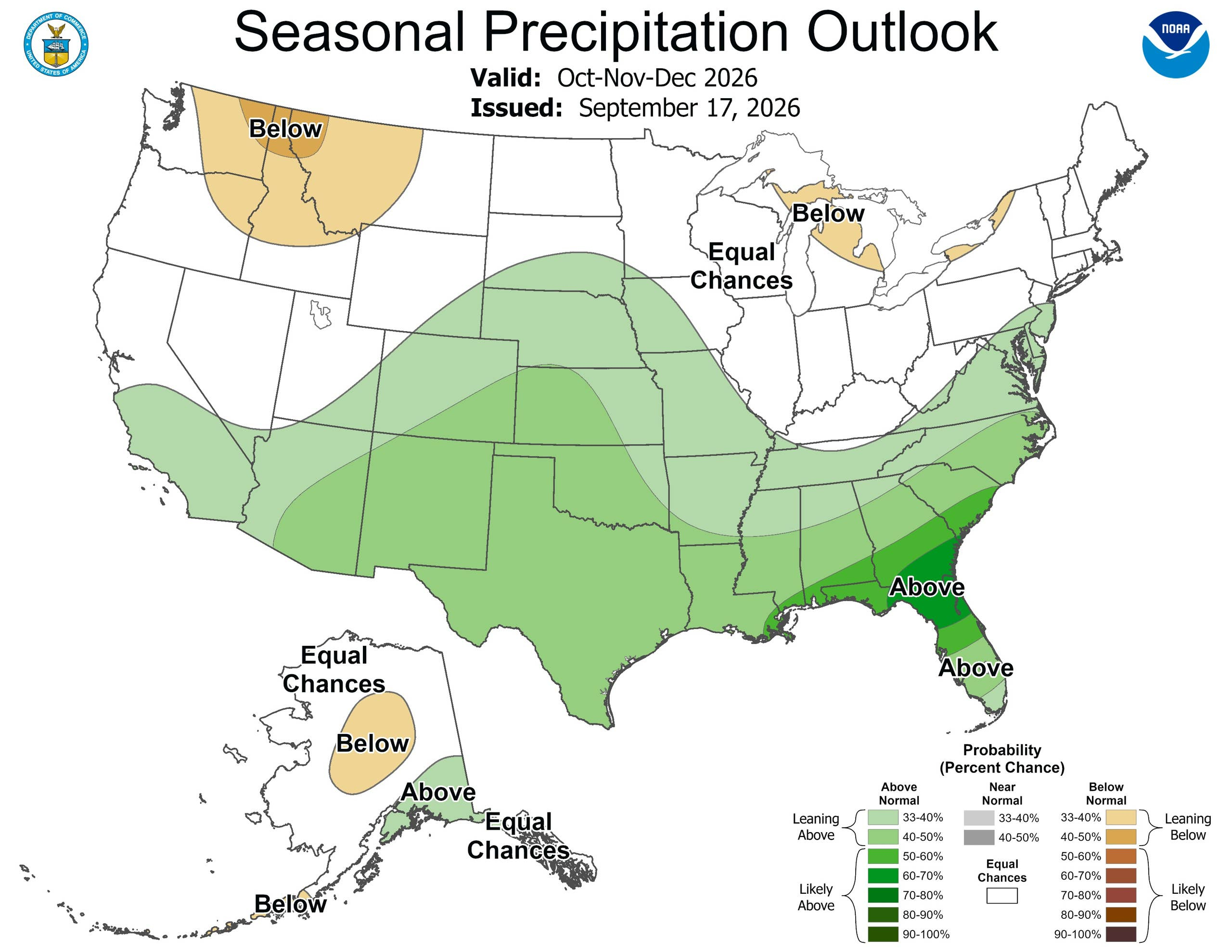
A “Godzilla-level” El Niño is building in the Pacific, and it’s about to rewrite the winter map. The National Oceanic and Atmospheric Administration (NOAA) puts the odds of a very strong El Niño at greater than 90% through fall and winter, with a 75% chance of it reaching historic strength from October through December. If that happens, it will be the strongest El Niño on record since 1950. For snow lovers, that means one thing: the storm track is about to shift dramatically south, and some regions are in for a banner season while others get left out in the cold, or rather, the mild.
The Big Winners: Southwest and Southern Rockies
The clearest signal for heavy snow points straight at the Southwest. California, Nevada, Utah, Arizona, New Mexico, and southern and eastern Colorado are all favored for above-average snowfall this winter. The Weather Company calls the Southern Rockies and Sierra “the jackpot of this winter,” predicting an active jet stream that will deliver frequent and consistent snow from Lake Tahoe to the Wasatch and the Colorado Rockies.
OpenSnow’s outlook specifically flags New Mexico as a standout, noting that historical trends favor a wetter and snowier winter across the state, including the Taos area. The heaviest snow is expected to fall from January through March, while December may see a slower start.
The Sierra Nevada: California’s Snow Machine
The Central Sierra has “the most evident signal for a snowier-than-normal season,” according to forecasters. Higher elevations in the Sierra Nevada are positioned to benefit from the more active southern storm track, where additional moisture can fall as snow rather than rain. For California’s ski resorts, which struggled through a brutal 2025-2026 season with historically low snowpack, this is a welcome reversal.
The Appalachian Corridor: A Cold and Snowy Battleground
While much of the country leans mild, the Appalachian region is a cold exception. The Old Farmer’s Almanac calls for colder-than-normal temperatures from central New England through the Appalachians and into the Ohio Valley, with above-normal snowfall particularly across the northern part of the region. Mid-January and mid-to-late February are projected to deliver the coldest periods.
Parts of the Appalachians could see a favorable setup: El Niño provides more moisture, while elevation offers a better chance of keeping temperatures cold enough for snow. Farther south and at lower elevations, that same storm may produce rain or ice instead.
The Northeast and Mid-Atlantic: A Complicated Mess
The Northeast is where the forecast gets tricky. The Farmers’ Almanac warns of a “mixed bag,” with coastal communities more likely to see rain and mixed precipitation while inland areas could face several rounds of heavy, wet snow, particularly in January and February. The Almanac cautions that “small shifts in storm tracks and temperatures could make the difference between rain, sleet, freezing rain, and accumulating snow.”
NOAA’s precipitation map favors wetter-than-normal conditions along the Atlantic Coast all the way into New England. If storms encounter sufficiently cold air, that moisture could translate to snow. The Mid-Atlantic could see an active winter storm track, though whether individual storms produce snow, rain, or a wintry mix will depend on temperatures at the time.
The Losers: Pacific Northwest and Northern Rockies
Not everyone wins in an El Niño winter. The Pacific Northwest, northern Rockies, and areas near the Great Lakes may be drier than normal. The Cascades, northern Rockies, and Montana often lean warmer and drier during strong El Niño winters, meaning fewer snow opportunities and warmer temperatures that can melt what does fall.
For Oregon and Washington, a “Super El Niño” could mean an even warmer and drier weather pattern than typical El Niño effects. That’s a tough pill to swallow for ski resorts in the Cascades that rely on consistent winter snowfall.
The Midwest: A Mixed Bag with Sharp Swings
The Midwest sits in a complicated zone. The Farmers’ Almanac forecasts cold, breezy weather with some snow at times, but also frequent swings between thawing and freezing conditions. The Great Lakes region is where the broad El Niño pattern can lean warmer and drier, but lake-effect snow depends on smaller details such as lake temperatures, wind direction, and the timing of cold air.
NOAA favors somewhat drier-than-normal conditions in parts of the interior Northwest and Great Lakes region. That doesn’t mean no snow. It means fewer opportunities for widespread snowstorms, with lake-effect bands potentially delivering localized heavy snow if cold air arrives at the right time.
The Bottom Line
The 2026-2027 winter forecast is defined by a Super El Niño that will push the storm track south. The Southwest, southern Rockies, and Sierra Nevada are the clear winners, with the potential for a banner snow season from January through March. The Appalachians and interior Northeast could see cold and snow, while coastal areas face a rain-snow battle. The Pacific Northwest and northern Rockies are likely to miss out, with warmer and drier conditions. As always, seasonal forecasts show probabilities, not guarantees. But if you’re a snow lover in New Mexico, Colorado, or Utah, this is your year.
Leave a Reply